Download this discussion sheet in Word format
Download this discussion sheet in pdf format
This discussion sheet considers:
- What crossings are,
- The basic options for managing crossing points,
- A range of simple, common crossing types, set out as a thought experiment that encourages readers to think about factors which might affect suitable safe, accessible options at a wide range of locations.
This discussion sheet does not contain answers: We hope that it will help inform ongoing discussions about how to provide safe and accessible crossing options for everyone who needs or wants to make walking/wheeling and cycling journeys.
1 What is a crossing?
There is currently no complete definition of “a crossing”, although some specific crossing types are defined in the Traffic Signs Manual chapter 6:
“There are three main types of crossing facility:
-
Uncontrolled or informal crossings; for example a pedestrian refuge or dropped kerb,
-
Zebra and Parallel crossings; which give pedestrians and cyclists a right of way over vehicles when on the crossing, and at which drivers must give way, and
-
Signal‑controlled crossings; which require drivers to stop at red lights, and which give users a push button to register the demand for a green signal.”
Without a single definition of “crossings”, we can end up discussing very different things!
We propose the following simple definition to cover all crossings:
“A crossing is any location where the paths of two different transport modes legitimately cross each other.” (Wheels for Wellbeing definition)
This includes all locations where motor vehicles are permitted to pass over a footway or a cycleway, all pedestrian desire lines over carriageways, and all locations where a cycle is permitted to pass over a footway. Less common crossing types involve routes for other transport modes – horse riding and horse driving, trains, trams and boats.
Prioritisation at all crossing points should be in line with the Highway Code hierarchy of road users.
To keep things simple, in this discussion sheet we will mainly focus on the most common types of crossing points for pedestrians and drivers – but the same broad ideas can be applied to any kinds of crossing points.
Further information and resources that are likely to be useful supplements to this document can be found on the Wheels for Wellbeing Resources page and include our guide sheet on walking/wheeling and cycling definitions, guide sheet on mobility aids and guide sheet on paths, pavements and roads.
2 The seven main crossing management options
Whether we’re thinking about existing streets and public spaces or about new designs, there are seven main options used to manage crossing points in the UK. Each option will have different effects on how accessible and how safe the location is for people walking/wheeling and cycling. Some options can be used in combination with others.
2.1 The seven main crossing management options – in pictures
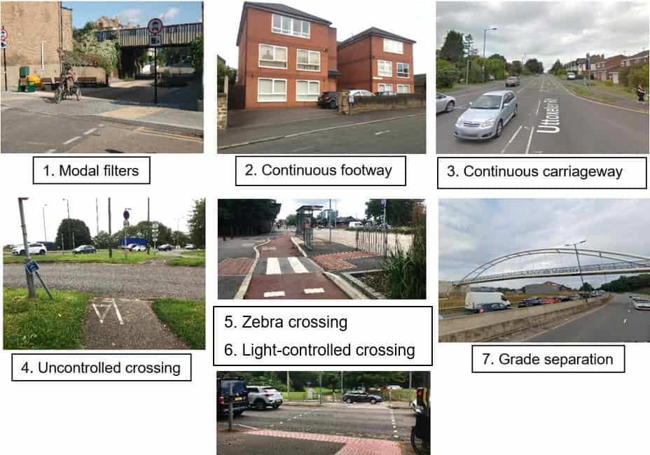
2.2 The seven main crossing management options – in words
- Modal filters prevent one or more modes from using the crossing – Stops the location from being a crossing for these modes, e.g. with a wall or “no vehicles” regulations. Can fully prioritise or fully prevent pedestrian or cycle movement, depending on design.
- Maintaining a continuous footway (and cycleway, as relevant) along desire lines through crossing point – Prioritises pedestrian movement. Suitable for locations with low driver numbers and speeds. Research is needed into how risk to pedestrians (and cyclists) changes as vehicle numbers and speeds increase, to establish when continuous footway is the most accessible and safe option, and when formal pedestrian crossing points should be installed.
- Maintaining a continuous carriageway along driver desire lines through crossing point – Deprioritises pedestrian (and cycle) movement, inaccessible for many Disabled people, unsafe for all pedestrians (and cyclists).
- Providing an informal, uncontrolled crossing point for pedestrians (and/or cyclists) – With a dropped kerb and buff tactile paving, with or without central refuge. Implicitly prioritises driver movement, likely to be unsafe for many pedestrians (and cyclists) to use in many locations, or less safe than other options.
- Providing a zebra (and parallel) crossing – Legally prioritises pedestrian (and cycle) movement; in practice, largely prioritises pedestrian (and cycle) movement. Difficult or unsafe for some Disabled pedestrians and cyclists to use especially in busier locations.
- Providing a signal-controlled crossing – with a range of possible effects on priority, safety and accessibility depending on control methods, timings and physical design. Likely to be relatively safe for pedestrians and cyclists to use.
- Providing grade separation of modes with a bridge or tunnel/underpass – if pedestrian and cycle movement is kept at-grade or close to grade, these can provide good prioritisation and safety from drivers, though careful design is needed to ensure social safety (personal safety from assault/harassment), especially in underpasses. Longer distances to travel, significant climbs, poor lighting and higher probability of closures due to severe weather compared to at-grade crossings can make grade separated crossings inaccessible to many Disabled people.
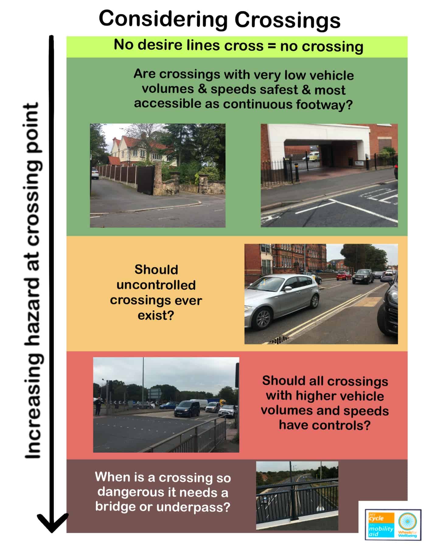
2.3 Considering crossings
3 From footway to motorway – which crossing options might suit which locations?
This section is a thought experiment, starting with the quietest, simplest crossing types and progressing to busier, more complex locations. Some crossing types are obviously inappropriate in some locations, but the important message here is that there are no clear-cut boundaries where one crossing type stops being appropriate and another instantly becomes the obvious best choice: Working out the best crossing options for a location is often complicated and nuanced. We believe that more research and discussion on safety and accessibility of different crossing types is needed, including fuller integration of means to reduce volumes and speeds of vehicles passing through crossings.
For each location discussed in the sections below, consider:
– Do you think a continuous footway, an uncontrolled or a controlled crossing would be the safest and most accessible option?
– What factors might change how safe and accessible different crossing types could be for different Disabled people walking or wheeling here?
– Could there be broader accessibility implications to consider around providing each different crossing type in this kind of location – could there be unintended consequences either here, or in the wider area?
– What formal evidence or experiences would help in making decisions about safe and accessible crossing options for different crossing locations? Does suitable evidence exist? What research might be needed?
There are many factors which might affect which crossing types you feel are suitable, including:
- How many vehicles cross the location per day or at peak times;
- How many pedestrians cross the location per day or at peak times;
- How fast drivers can pass over the crossing location – which may be affected by crossing widths, slopes, markings and any access controls such as bollards or gates;
- How fast people drive on any nearby roads;
- How noisy the location is;
- How good sight lines are;
- Whether the crossing near to schools or other key destinations;
… and so on.
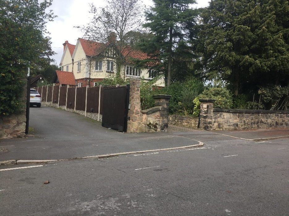
Let’s start by thinking about the simplest common type of crossing: Driveways.
Driveways are generally places that are deprioritised for drivers, with continuous more-or-less level footway and no tactile indication that the driveway is there. There may be a change in pavement crossfall at driveways: This can give some drivers the impression that their access is prioritized over that of pedestrians, and will make using the location more difficult for some Disabled people… And the change in crossfall may also provide useful information about the crossover existing to some Disabled people.
We can only work out which crossing types are safest and most accessible at which kinds of locations by considering all types of crossings – from places where one driver may pass over a footway each day or even each week, to places where dozens of drivers per minute pass a point where pedestrians and cyclists need to cross a road.
In the most simple situation, a driveway serves one home:
3.1 A driveway serving one home:
Somewhere between two and five vehicle movements are likely to occur per day per household on average – so working with a nice round number of four, we would expect a car to cross the footway once every six hours or so per single-home driveway. In the photo below, one of the two driveways has a continuous footway across its entrance. The other has kerbs crossing the footway, giving drivers a continuous carriageway just like a standard side street access, even though the driveway leads to just one home
How do you think crossings should be managed at this kind of location, and why do you think this?
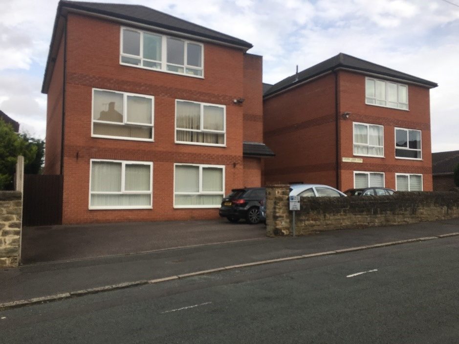
3.2 A driveway serving more than one home:
In the photo below, a driveway leads to a block of apartments with associated parking. A common situation is where a single large house has been replaced or converted into multiple homes.
There are around 10 homes beyond this driveway crossing, so we’re now expecting about 40 vehicle movements per day over the footway. If we assume all those occur in two “rush hours”, that’s 20 vehicles crossing the footway per hour – one vehicle every three minutes.
How do you think crossings should be managed at this kind of location, and why do you think this?
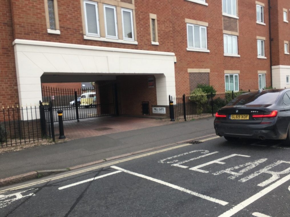
3.3 An apartment block of 30 homes:
Now our photo shows a bigger apartment block, perhaps with around 120 vehicle movements per day. If we assume again that every vehicle movement occurs within two “rush hours”, that’s about one car crossing the footway per minute during the busiest two hours, and no cars crossing the footway for 22 hours per day.
Again, how do you think the driveway crossing should be managed at this kind of location, and why do you think this?
What features of the crossing could make it safer, more accessible or both for different user groups?
Could some features meant to improve safety in reality make a space less safe, or less accessible? How and why might this happen?
3.4 What if our apartment block is actually a cul-de-sac of 30 houses?
We still have one car crossing per minute for two hours of the day (and none the rest of the day).
Is this a different situation for crossing the “driveway” – which will now be called a side street – from when it was an apartment block?
What features might make the cul-de-sac side street crossing different from an apartment block driveway crossing?
If you thought a continuous footway was suitable for the 10 or 30 house apartment block, but not for a cul-de-sac with the same number of vehicle movements per day, what are the differences which change your decision?
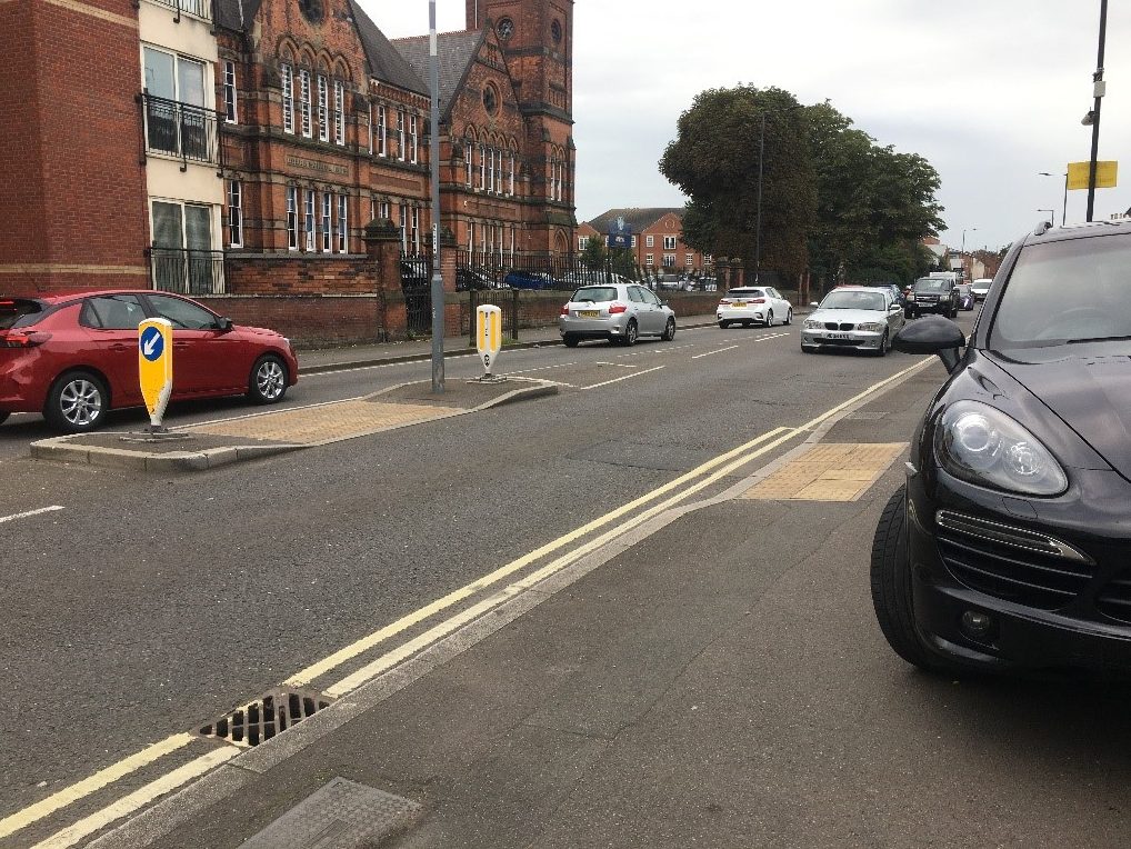
3.5 What if the “driveway” leads to a smallish local supermarket?
A small Tesco Express, Sainsburys Local or similar with a fairly small car park might have about 60 vehicles crossing the footway per hour, one per minute, all day every day. This might be comparable to a large GP surgery or health centre, or a big pub’s car park on a fairly busy day.
Is it reasonable to have a continuous footway, an uncontrolled or a controlled crossing here?
At crossing locations like this, where vehicle volumes are fairly low and pedestrian volumes likely to be fairly high, should any crossing controls used give a default green to pedestrians and only permit drivers to cross after a vehicle is detected? This is how many vehicle junction traffic light sensor systems work – and is a simple reversal of the pedestrian “beg-button” principle that most controlled crossings in the UK use.
Would it be reasonable to give default pedestrian green signals at controlled crossings with much higher vehicle volumes or with lower pedestrian numbers? In what situations might it be reasonable to give pedestrians a default green?
3.6 What about a much larger supermarket, shopping centre or hospital?
What happens when on average two vehicles cross the footway per minute? Or four vehicles? What about ten vehicles per minute – one every six seconds, all day?
Different people will have different ideas about when a controlled crossing becomes essential for themselves and for other people walking/wheeling – determined by some combination of their own perception, speed and risk tolerance, and the speeds and frequencies of vehicle movements.
To create an accessible, equitable public realm, we believe that research is needed to develop evidence on what crossing types really can make crossing locations as safe, legible and accessible as possible for everyone walking and wheeling.
3.7 What if the crossing point has a vehicle crossing it every few seconds – but only for a short periods?
A pattern of high numbers of vehicles crossing a footway for short periods then almost no vehicles crossing the rest of the time happens at schools, many workplaces, sports stadia and other cultural venues. The times when lots of drivers want to access the site are often the same times that many pedestrians want to go there, too.
How can sites like this be made safe for pedestrians using the footway and accessing the site at busy times and at quiet times? Are measures used to improve pedestrian safety the same as measures which will improve accessibility? Will measures to improve safety and accessibility inevitably support more people to walk/wheel and cycle journeys – or could some safety and/or accessibility measures decrease the numbers of people who use a route?
3.8 What should happen when vehicle speeds and volumes increase?
So far, we’ve thought about fairly low-speed situations, where it’s feasible to assume that average vehicle speeds over the crossing point will be – or at least, could be engineered to be – well below 20mph and preferably as low as walking speed. The Cycling Level of Service Tool (CLoS), figure 4.1 (appropriate protection from motor traffic on highways) and figure 10-2 (crossing design suitability) in LTN 1/20 provide a helpful framework to start thinking about increasing vehicle speeds and volumes for the context of larger roads:
3.8.1 For quiet, 20mph streets with fewer than 2500 vehicles per day
LTN 1/20 states that roads with vehicle speeds under 20mph and fewer than 2500 vehicles per day are sufficiently safe for cyclists to share the carriageway with motor vehicles, and that uncontrolled crossings will be accessible for most users. These streets will be quiet, often residential streets, with a few vehicles passing per minute during the day.
In these kinds of locations, how can crossing points be engineered to slow drivers enough and provide all pedestrians with enough information to cross safely? Are continuous footways, uncontrolled or controlled crossings needed? Would grade separation with bridges or tunnels be safer and more accessible – or are the harassment and assault risks and accessibility reduction from pedestrian bridges and tunnels worse than any safety benefits pedestrians would gain from being separated from drivers? What conflicting safety and accessibility factors need to be taken into account and mitigated?
3.8.2 Busier streets in villages, towns and cities with speed limits 20-30mph.
Once roads have 85th percentile speeds 20-30mph OR 2500-5000 average vehicles per day, as long as under 2% are HGVs, LTN 1/20 states that sharing space with vehicles and uncontrolled crossings will be inaccessible to some people. This implies that controlled crossings or grade separation (bridges or tunnels) are needed.
If national guidance is warning that crossings in these locations will be inaccessible to some people if there are not signal controls – and given that the people most likely to be unable to cross without signal controls are also most likely to have protected characteristics – would local authorities failing to put controlled crossings or grade separation in at these locations be breaching the Equality Act 2010 Public Sector Equality Duty?
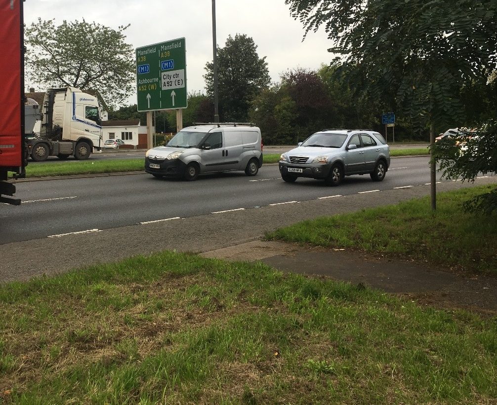
3.8.3 Very busy streets in villages, towns and cities:
Once roads have 85th percentile speeds over 30mph or over 5000 vehicles per day or more than 2% HGVs, LTN 1/20 says that sharing space with vehicles will be inaccessible for most people, and that either controlled crossings or grade separation are needed.
There are still many locations around the UK where roads with very high speeds and traffic volumes have uncontrolled crossings – including on 70mph dual carriageways. These uncontrolled crossings are usually found where rural footpaths or urban desire lines intersect busy A roads, which will generally have been much less busy when the road was built. These crossings will be completely inaccessible to most people. Should they be replaced with controlled crossings or grade separation, or blocked off altogether, fully cutting off some historic pedestrian rights of way and useful desire lines?
3.9 What about rural roads?
Rural roads make up most of the length of our road network – and while it may be possible to take alternative routes in a city if one road is too busy or dangerous, in rural areas there often are no alternative options.
LTN 1/20 recommends that cyclists need fully kerbed separate routes on all roads with speed limits from 40mph and above, and that grade separation at crossings (bridges or underpasses) is needed where speed limits or vehicle speeds are equal to or above 60mph, no matter how low the traffic flow. We believe that people walking/wheeling need at least as much protection from motor traffic as people cycling do.
Many small rural roads are delimited, with default 60mph limits, yet they often don’t even have pavements, let alone any designated crossing points.
How can we improve accessibility of rural routes to people walking, wheeling, cycling and riding, especially at locations where people need to cross, not simply move along, a carriageway with no safe active travel provision and/or no controlled crossing points?
Should we demand greatly reduced speed limits for smaller rural roads or for all roads with no safe, separated walking/wheeling and cycling options, unless or until safe and accessible protected infrastructure can be created?
3.10 What about pedestrian/cycle route crossing points?
So far, we’ve only talked about crossings involving motor vehicles.
We need to consider crossings where cycle and pedestrian flows intersect – where footways and cycleways cross. This frequently happens with separate cycle and pedestrian infrastructure near to controlled road crossing points and at public transport infrastructure, particularly bus stops (bus stop bypasses and bus stop boarders).
7 A cycle track, footway and bus stop interact at a bus stop bypass
We know that few deaths or serious injuries occur from collisions between pedestrians and cyclists, relative to the deaths and serious injuries from collisions involving motor vehicles.
We also know that many pedestrians – and especially Disabled, younger and older pedestrians – are being intimidated and put at risk of injury by some fast-moving and inconsiderate cyclists, micromobility users and even by some powered mobility aid users, particularly in shared spaces and at crossing points where cyclists and other faster space users fail to give way appropriately to pedestrians.
Ensuring crossings of pedestrian and cycle routes are safe, accessible and not intimidating is important, because some Disabled people are being prevented from making journeys walking/wheeling and using public transport due to the risk and fear of being injured at these locations – and the people being prevented from making these journeys are often people who have no alternative travel options.
4 What we’d like to happen next:
We hope this thought experiment has raised some interesting points for you. We think that there are a lot of factors that need to be taken into consideration to ensure that our streets and public spaces are made as safe and as accessible as possible for all Disabled people:
We want to see co-produced research into the infrastructure, education, regulatory and enforcement measures that need to be taken to ensure that all Disabled people can make the journeys we want and need to, when we want to make them, using transport modes that work for us, safely, at reasonable cost and in a timely fashion, in line with the United Nations Convention on the Rights of Persons with Disabilities and the Equality Act (2010).